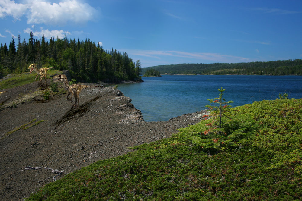
 Here's one to startle you. Edwards Island, Isle Royale, at the northeast end of Tobin Harbor, and over the ridge comes a pair of dangerous velociraptors. Yes, this is a bit of digital chicanery, done to one of my own photos by my 14-year-old son Logan, who can be found in other annual Isle Royale slide shows. Log' has been working with Photoshop Elelments lately, and he's made a few Isle Royale dino shots. There was no island in this location, science has decided, 65 million years ago, when the dinosaurs ruled. Still, the ridges that form the island today did exist back then, having been created hundreds of millions of years before the dinosaurs inhabited the Earth. Those ridges came into being when the vast solidified lava lakes of the Great Midcontinent Rift (which occured about 1 billion years ago and was located, in part, where Lake Superior now lies) became so heavy that the crust of the Earth sank into the mantle and the ends of those dozens of layers of cooled lava bent upward. Those massive, miles-upon-miles-wide, broken, bent-up slabs of the Earth's crust formed the ridges of the Keweenaw Peninusla to the southeast and of Isle Royale to the northwest, as though they were the rims of a bowl. Dinosaurs lived in areas not so distantly west of the Lake Superior region, and at the same latutude. I have never read, however, whether dinorsaurs once hiked the ridges that would become the bones of Isle Royale tens of millions of years later. It was a mere 10,000 years or so ago that the last great Ice Age created the glaciers that formed Lake Superior and the island, which was made a national park of the United States in 1940.
2006 Slide Show, Photo 7
Here's one to startle you. Edwards Island, Isle Royale, at the northeast end of Tobin Harbor, and over the ridge comes a pair of dangerous velociraptors. Yes, this is a bit of digital chicanery, done to one of my own photos by my 14-year-old son Logan, who can be found in other annual Isle Royale slide shows. Log' has been working with Photoshop Elelments lately, and he's made a few Isle Royale dino shots. There was no island in this location, science has decided, 65 million years ago, when the dinosaurs ruled. Still, the ridges that form the island today did exist back then, having been created hundreds of millions of years before the dinosaurs inhabited the Earth. Those ridges came into being when the vast solidified lava lakes of the Great Midcontinent Rift (which occured about 1 billion years ago and was located, in part, where Lake Superior now lies) became so heavy that the crust of the Earth sank into the mantle and the ends of those dozens of layers of cooled lava bent upward. Those massive, miles-upon-miles-wide, broken, bent-up slabs of the Earth's crust formed the ridges of the Keweenaw Peninusla to the southeast and of Isle Royale to the northwest, as though they were the rims of a bowl. Dinosaurs lived in areas not so distantly west of the Lake Superior region, and at the same latutude. I have never read, however, whether dinorsaurs once hiked the ridges that would become the bones of Isle Royale tens of millions of years later. It was a mere 10,000 years or so ago that the last great Ice Age created the glaciers that formed Lake Superior and the island, which was made a national park of the United States in 1940.
2006 Slide Show, Photo 8
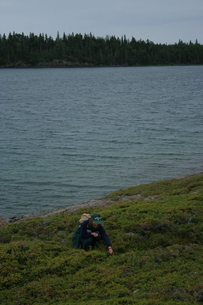
This shot was taken on the same day as Slide 6 of my son Drew. This time, though, I give you a shot of my wife Marsha, nestled down in broad carpets of juniper, picking blueberries on Long Island, just up Tobin Harbor from Porter Island. That's Edwards Island in the distance across the harbor.
2006 Slide Show, Photo 6
 This is my son Drew, now 11 years old, picking blueberries on Porter Island near the northeast end of Tobin Harbor in late August. I think it's interesting that Drew looks as though he is picking juniper berries. Often, wild blueberry plants are tangled with spreading juniper on Isle Royale's ridges and outcroppings. Most of the blueberries, Drew is telling me as I type here in Mason, MI, on Christmas Day, were yet to ripen. My memory is different. I thought we found plenty and that they were in pretty good shape. Maybe it was just the location he was picking in, up high on the ridge that forms Porter Island. In any case, we had a great time, picking and exploring and cruising the harbors and coves, even though the rain was spitting.
2006 Slide Show, Photo 5
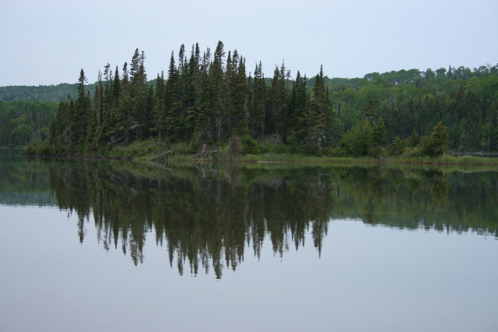
A quiet evening along Tobin Harbor. It was late summer, and I was snooping for moose, and so staying very, very quiet. None were to be heard or found, but the subtle beauties of Isle Royale on a day of heavy cloud-cover were on display. I love and cherish these calm moments late on a gloomy day, just before the gloaming (to offer a bit of heavy-handed alliteration for all present and former English majors out there). There was hardly a sound, except for the occasional bleat of a loon or two far away up the harbor. It would rain a bit later, but these moments along this passage among Tobin islands near Thompson Island have become a special memory.
2006 Slide Show, Photo 4

What a glorious spring on Isle Royale it was in 2006. Spring in summer? you ask. Well, yes. Spring on the island comes about 4 weeks later than elsewhere in northern Michigan, so in June we are still in spring on Isle Royale, though we call it summer. To repeat, things have been dry, near drought in the Lake Superior Basin for some time. But there has been just enough rain at just the right times to have some beautiful spring conditions here and there, such as along the Tobin Harbor Trail, where I took this shot of a hearty phalanx of bunchberries, or Canada dogwood. Note the dense stand of spruce along this section of trail, not an uncommon site along the northeast harbors. Such thickets are the indirect result of moose gluttony, since their love of balsam fir strictly represses the growth of balsam, which gives spruce the power to dominate. This is changing, though. With the moose population down for almost 10 years now, stands of balsam have once again gained a toehold here and there in areas that the spruce once thought secure for their own kind.
2006 Slide Show, Photo 3
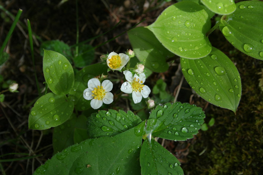 Taken along the Scoville Point Trail in late June. These are wild strawberry flowers in the sunshine after a short afternoon rain. The island continued to suffer near-drought conditions throughout most of the summer, however. The strawberry crop turned out rather poor. I must admit, though, that the raspberries and the blueberries both came in with excellent crops in summer 2006. That's a bit odd, since I was expecting raspberries to flourish in the dry weather and blueberries to get quickly burned out. But a few days of brief rain at the right time seemed to save the blueberries. More on this coming later.
2006 Slide Show, Photo 2
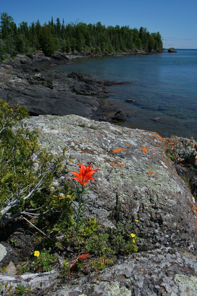
In July, I took a paddle by canoe out to Laurel Lei Lane (I'm unsure of the spelling, by the way) and visited the shallow, narrow gap between Shaw and Smithwick Islands. This shot is from Shaw looking northeast toward Smithwick on a spectacular Isle Royale summer day. That, of course, is a wood lily in the foreground. This is a favorite place for me on IR -- the whole of Laurel Lei Lane, I mean. (Well, perhaps I should point out that I have a hundred or so "favorite" places on IR, so I don't how meaningful the adjective is in this context. I suppose my favorite of favorites is the place I happen to be in at any one moment.) It runs from Raspberry Island on the NE to Mott Island on the SW about 4 miles or so. I am often found paddling out in the Lane on a summer's day. Shaw Island doesn't seem to get quite as much traffic as Smithwick Island. Shaw is almost all solid rock on its edges, as shown in this photo, whereas Smithwick has a few cobble beaches to land a canoe or kayak.
2006 Slide Show, Photo 1
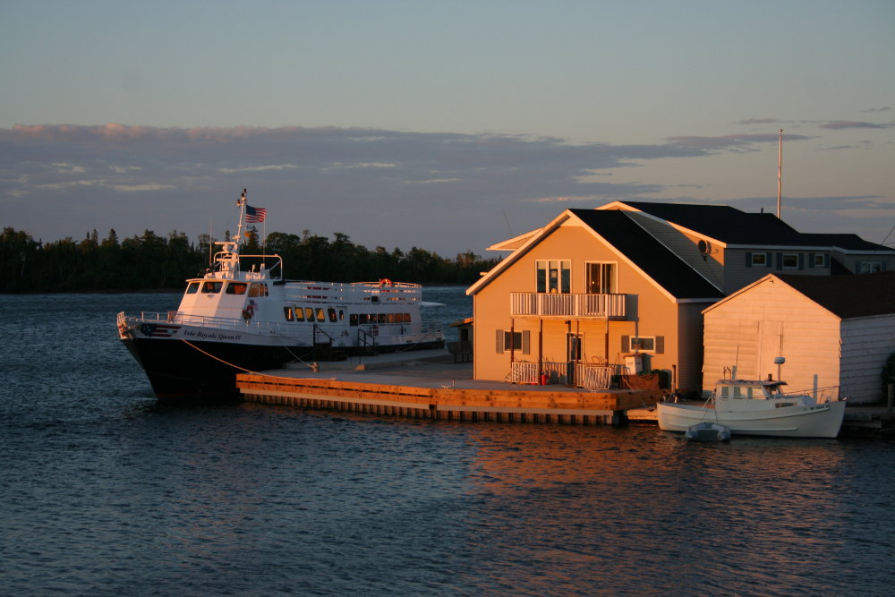
Let's start out this year's slide show with a shot in Copper Harbor of the new Isle Royale Queen IV at the Queen dock in the center of town. 2006 was the first full summer of operation for the Queen IV. But notice the brand-new dock, which was yet another improvement to the service provided by the Kilpela family. We had a great year with the new boat. People seemed to be very pleased with the much faster service to the island -- just a little more than 3 hours one-way. And we took many more day-trippers to the island than ever before. She takes the seas a bit better, too, and people always appreciate that. The Queen IV is a little more than 100 feet long, tip to tip. We're considering more improvements in the next few years.
Introduction
Here's a new way to put up my annual slide shows and let you comment on the slides or any other matter and send your own Isle Royale photos, if you wish. I'm Captain Ben Kilpela, of the family that owns the Isle Royale Queen IV, the 100-foot vessel that sails from Copper Harbor, MI, to Rock Harbor on Isle Royale nearly every day in summer. I have posted annual slide shows on my Isle Royale web site for some years (a link is on the front page of this blog), but I decided to put up this blog as a new way to present those slide shows and share news, happenings, and reflections on Isle Royale, Michigan's only national park and one of the only two island national parks in the United States. Welcome to the blog.
Subscribe to:
Posts (Atom)
